One of the most common questions we field from developers and architects, especially those working within tight pre-planning budgets, is exactly the kind of decision captured in Drone Photomontage CGI vs Fully 3D Modeled Environments: Which Context Option Fits Your Development Planning Budget? It sounds technical, but it really comes down to this: do you drop a photorealistic 3D building into a real photograph of the site, or do you build the entire surrounding environment from scratch inside the 3D software? Both approaches produce compelling planning visuals. But they cost differently, take different amounts of time, and work better in different situations. Getting this choice wrong wastes money — and in some cases produces visuals that actually undermine a planning submission rather than supporting it.
We’ve worked on schemes ranging from single-dwelling householder applications to large mixed-use masterplans, and the context method is something we discuss with almost every new client. The right choice isn’t always the more expensive one. In fact, for many development planning scenarios, a well-executed drone photomontage will outperform a fully 3D environment on both realism and credibility — simply because it uses the actual site. But there are specific situations where full 3D environments are not only preferable but genuinely necessary. Let’s break down how each approach works, what it actually costs in terms of time and production effort, and how to match the method to your project stage and audience.
What Is a Drone Photomontage CGI and How Does It Work?
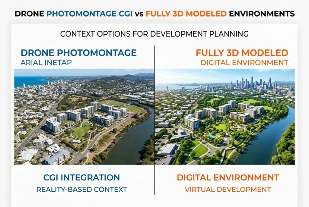
A drone photomontage — sometimes called a photo-merged CGI or photomontage visual — takes a real aerial or street-level photograph of the existing site and composites a fully rendered 3D model of the proposed building into it. The photograph provides the environment: the surrounding streets, neighbouring buildings, trees, cars, sky. The CGI provides the new development. When done properly, the two are matched in perspective, scale, lighting angle, lens distortion, and atmospheric depth so that the rendered building appears to sit naturally within the real photograph.
The technical process requires a calibrated drone flight or DSLR shoot at the actual location. We use photogrammetry data or manual camera matching to align the 3D camera view precisely with the real photograph. The building model is rendered with lighting that matches the photograph’s ambient conditions — time of day, sky colour, shadow direction. Post-production compositing then brings it all together, blending edges, matching colour grading, and ensuring ground contact shadows are consistent. If the real photo has soft overcast light, the render needs to match that. If the photo shows sharp midday shadows, the 3D lighting must mirror it. The integration is everything.
For planning purposes, this approach has one enormous advantage: it shows exactly where the building will sit, relative to real neighbours, real street widths, real tree canopy. Planning officers can look at the visual and immediately orientate themselves. They know that street. They can compare the proposed scale against the existing context. That grounding in reality is hard to replicate with a fully invented 3D environment.
Understanding why context matters in architectural rendering how streetlevel surroundings and people make or break a development visual is fundamental to choosing the right method — and the photomontage approach is often the most direct way to deliver credible context.
What Is a Fully 3D Modeled Environment and When Does It Make Sense?
A fully 3D modeled environment means the entire scene — building, roads, surrounding structures, landscaping, people, sky — is built and rendered entirely inside 3D software. Nothing comes from a photograph. Every element is modeled, textured, lit, and rendered as a single unified 3D scene.
This approach gives artists complete creative control. Want to show the development on a bright spring morning with pedestrians using the public realm, even though the site is currently a gravel car park on a grey industrial estate? You can do that. Want to show the proposed building looking its absolute best from a view that doesn’t physically exist because there’s a temporary hoarding blocking it? 3D gives you that freedom. For masterplan aerial views, for artist’s impressions used in investor presentations, for marketing material that needs to show vision rather than strict planning accuracy — fully 3D environments are the right tool.
This is especially relevant for 3d rendering for masterplan developments how urban designers present largescale mixeduse sites to local authorities, where the surrounding environment may itself be subject to change as part of the wider scheme. Rendering a 200-unit development into a real drone photo makes sense when the site context is stable. When half the surrounding buildings are also being demolished and replaced, a photomontage becomes misleading — a fully 3D environment gives you the control to show the future state accurately.
The trade-off is production time and cost. Building a convincing fully 3D environment takes significantly more work than the photomontage route. Modelling surrounding buildings, generating procedural road surfaces, populating the scene with realistic trees, vehicles, and entourage figures — all of that adds up. For a constrained pre-planning budget, it’s worth asking whether you actually need that level of build.
Drone Photomontage CGI vs Fully 3D Modeled Environments: Which Context Option Fits Your Development Planning Budget?

The honest answer: it depends on three things — the stage of the project, the audience for the visuals, and the nature of the site context itself.
| Factor | Drone Photomontage CGI | Fully 3D Environment |
|---|---|---|
| Production time | Lower — environment already exists | Higher — full scene must be built |
| Cost | Generally lower per render | Higher due to environment modeling |
| Planning credibility | Very high — real site context | Moderate — clearly an artist’s impression |
| Creative control | Limited — tied to existing conditions | Complete — full scene control |
| Best for | Planning submissions, consultations | Marketing, investor decks, masterplans |
| Site condition requirement | Stable, photographable context needed | Works regardless of site condition |
At feasibility stage, where budgets are tightest and design is still evolving, we’d often recommend a drone photomontage for the key street-level view combined with a simpler aerial context image. If you’re presenting to a planning committee who know the area, seeing a real photograph with your building in it lands harder than a polished but clearly synthetic environment. For investors, lenders, or marketing — particularly off-plan sales where you want the scheme to look aspirational — the fully 3D route gives you the freedom to tell a story.
We also discuss this in the context of thinking carefully about single render vs full cgi pack what budgetconscious developers should prioritise at feasibility stage — because the context method choice and the number of renders you commission should be decided together.
Technical Considerations That Often Get Overlooked
There are some practical production details that clients don’t always anticipate when choosing between these two methods.
Drone photography quality matters enormously for photomontage. A blurry, low-resolution, or poorly timed drone shot will undermine the entire composite. We need RAW format images, shot in good light with a known focal length so we can camera-match accurately. If a client provides a phone snapshot or a low-res Google Maps screenshot, the resulting photomontage will look unconvincing no matter how well the building is rendered. Either commission a proper drone shoot or factor that into the brief.
The scale of the proposed building relative to surroundings affects which method works. A four-storey residential block in a dense urban street? Photomontage is ideal — the real surrounding context tells the planning story. A 25-storey tower on a cleared brownfield site with no established streetscape nearby? You may end up building a full 3D environment anyway, because the photomontage lacks context worth showing. And for schemes like this, aerial 3d rendering for planning applications how dronestyle visualisations are changing development approvals is worth understanding as a hybrid approach that bridges both methods.
Revisions are handled very differently between the two methods. With a photomontage, if the architecture changes significantly, the 3D model is updated and re-rendered into the existing composite. That’s manageable. But if the view angle needs to change — if you want to see the building from a different direction — a new drone photograph has to be taken. That means a return site visit, rescheduling around weather, potentially weeks of delay. With a fully 3D environment, you can spin the camera to any view with no additional site work. That flexibility has real value for projects where multiple viewpoints are needed or the design is still evolving.
What Clients Get Wrong

The most common mistake we see is clients choosing the method based on which sounds more impressive rather than which serves their actual submission or presentation goal. “Fully 3D” can sound more premium, so some clients automatically assume it’s better. In reality, for a straightforward planning application on an urban infill site, a well-executed photomontage will often be more persuasive to a planning officer than a glossy but obviously synthetic 3D environment. Planning committees are increasingly accustomed to CGI, and they know the difference between a real photo base and a fabricated one.
The second mistake is trying to save money on the drone shoot and then wondering why the photomontage looks wrong. The photography is not an optional extra — it’s the foundation of the entire visual. Cutting corners there is like buying expensive tiles and laying them on a cracked floor.
The third mistake is applying a single method to an entire project regardless of what each specific image needs to communicate. A sensible CGI strategy might use photomontage for the close-range street-level view, a fully 3D aerial for the masterplan overview, and a hybrid approach for mid-range contextual shots. Mixing methods within a project is completely normal and often the most cost-effective approach.
If you’re also considering how the final images will be delivered and used — for print, for web, or as part of a formal planning submission — it’s worth reading about what file formats should a 3d rendering studio deliver and why it matters for print web and planning submissions, because the technical specifications for planning submissions can differ significantly from marketing outputs.
Making the Right Choice for Your Project
Here’s a practical decision guide based on what we’ve seen work across a wide range of project types:
- Choose drone photomontage when the site has an established, recognisable street context, when the audience includes planning officers who know the area, when budget is constrained, and when you need maximum planning credibility from a single image.
- Choose fully 3D environment when the surrounding context is changing as part of the scheme, when the site is isolated or featureless, when you need multiple camera angles without returning to site, when the output is for marketing or investor use rather than planning submission, or when you want complete control over lighting and seasonal conditions.
- Consider a hybrid approach for larger schemes where different images serve different audiences — real photo bases for planning views, full 3D for aerial overviews and marketing.
The decision isn’t really about which method is “better.” It’s about matching the production approach to the specific job the image needs to do. A planning officer needs to believe what they’re seeing is an accurate representation of how your building will affect the real environment. An investor needs to feel excited about what the finished scheme will become. Those are different emotional and evidential tasks, and they sometimes call for different tools.
If you’re working through this decision for an upcoming planning submission or development brief, the team at 360archviz.com would be glad to look at your project and recommend the approach that fits your timeline and budget. Contact us to discuss your project, or explore our aerial 3d rendering service to see examples of both photomontage and fully 3D context work in practice.
Frequently Asked Questions
What is the difference between drone photomontage CGI and fully 3D modeled environments for development planning?
Drone photomontage CGI combines real aerial photography captured by drones with digitally inserted 3D models of proposed structures, creating a realistic blend of existing and planned environments. Fully 3D modeled environments, on the other hand, are entirely computer-generated scenes built from scratch without relying on real-world photography. The key difference lies in cost, production time, and the level of realism, with photomontage typically being faster and more cost-effective for projects in existing urban or rural contexts.
How much does drone photomontage CGI cost compared to a fully 3D modeled environment for a planning application?
Drone photomontage CGI generally costs less than fully 3D modeled environments because it leverages real drone footage as a base, reducing the time needed to build detailed background scenes from scratch. A typical drone photomontage project for a single planning view can range from £500 to £3,000 depending on complexity, while a fully 3D modeled environment for the same scope can range from £2,000 to £10,000 or more. The cost gap widens significantly when multiple viewpoints, complex landscapes, or interior walkthroughs are required.
When should a property developer choose a fully 3D modeled environment over drone photomontage for planning visuals?
A fully 3D modeled environment is the better choice when the development site is largely undeveloped, when the surrounding context does not yet exist, or when the project requires future-state visualizations that cannot be accurately represented with current drone imagery. It is also preferred for projects requiring animated walkthroughs, interior and exterior sequences, or highly controlled lighting scenarios for marketing and stakeholder presentations. Developers with larger budgets seeking premium-quality visuals for major planning applications or investor pitches will typically benefit most from the full 3D approach.
Is drone photomontage CGI accepted by local planning authorities for development applications in the UK?
Yes, drone photomontage CGI is widely accepted by local planning authorities (LPAs) in the UK, particularly when produced in accordance with the Landscape Institute's Visual Impact Assessment guidelines and other relevant planning standards. The method is considered highly credible because it uses verified, georeferenced photography as a base, which demonstrates accurate placement of proposed structures within their real context. However, applicants should always confirm specific visual representation requirements with their LPA early in the planning process to ensure compliance.
Which option provides a better return on investment for small to medium-sized development projects?
For small to medium-sized development projects, drone photomontage CGI typically offers a stronger return on investment because it delivers planning-grade visuals at a fraction of the cost of full 3D modeling. The faster turnaround time also means developers can respond quickly to planning authority requests or public consultation requirements without significant budget strain. However, if the project involves significant marketing activity, investor engagement, or complex site conditions, the additional spend on a fully 3D modeled environment may be justified by the higher quality and versatility of the output.


