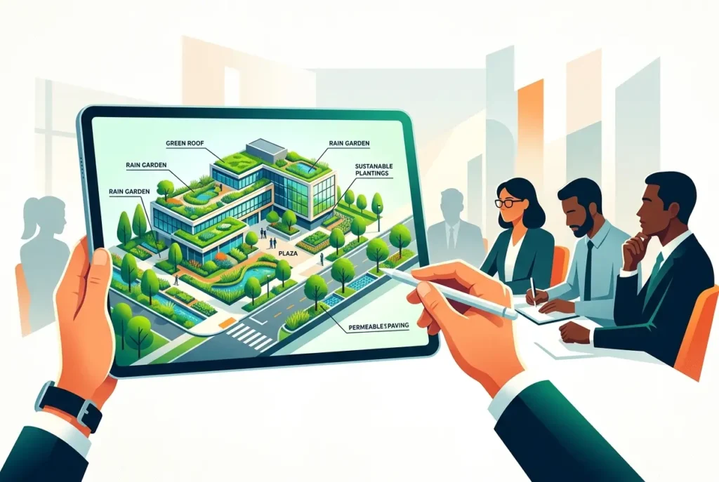
Green infrastructure is one of the hardest things to sell in a planning meeting. You’re asking a committee of non-specialists to approve something they can’t fully picture — rain gardens, bioswales, green roofs, permeable paving, tree canopy corridors — using nothing but technical drawings, cross-sections, and written reports. Most people on those committees aren’t landscape architects. They’re councillors, planners, community representatives. They respond to what they can see and understand. That’s exactly why understanding how landscape architects use 3D exterior renderings to communicate green infrastructure to planning committees has become one of the most practically important topics in our field right now. The gap between a beautifully designed green infrastructure proposal and a confident planning approval often comes down to one thing: the quality of the visual communication.
In our studio, we work with landscape architects and urban designers on a wide range of projects — from urban park upgrades to large-scale masterplans incorporating sustainable drainage systems and biodiversity net gain requirements. What we’ve seen consistently is that the technical accuracy of a design rarely determines its outcome in committee. What drives the decision is whether the committee can mentally place themselves inside the finished space. Green infrastructure, with its layers of ecological function and spatial character, is particularly difficult to communicate on flat drawings. A 3D exterior rendering collapses that cognitive gap almost instantly.
This post is a working explanation of how the best landscape architects are using 3D exterior visuals to make green infrastructure legible, credible, and genuinely compelling to the people who control planning decisions. It also covers what to avoid — because poor visuals can do more damage than no visuals at all.
Why Green Infrastructure Is Harder to Present Than Built Form
When an architect presents a building, the audience already has a mental model. Four walls, a roof, windows, a door. Even abstract architecture lands relatively quickly because the basic typology is familiar. Green infrastructure doesn’t have that advantage. A bioswale looks like a ditch to most people. A rain garden looks like an overgrown patch. A tree canopy plan looks like dots on a map. None of those things communicate the lived experience of walking through a shaded, flood-resilient, ecologically rich corridor at street level.
This is why 3D exterior renderings are doing so much heavy lifting in landscape planning submissions right now. A well-constructed rendering can show the bioswale at full maturity — planted, functioning, integrated into the pedestrian realm — with people using the space around it. It shows the committee not just what the green infrastructure is, but what it feels like. That’s a fundamentally different kind of information, and it’s the kind committees actually act on.
The context surrounding those green elements matters enormously. A rendering that shows a green roof without the street below, or a planted median without the traffic and pedestrian movement around it, loses most of its communicative power. We’ve written more broadly about why context matters in architectural rendering how streetlevel surroundings and people make or break a development visual — and for green infrastructure specifically, that principle applies at every scale.
How Landscape Architects Use 3D Exterior Renderings to Communicate Green Infrastructure to Planning Committees: The Core Techniques
There are a few specific rendering approaches that consistently perform well in planning committee presentations. They’re not complicated, but they require deliberate choices — choices that need to be made before the brief goes to a rendering studio.
Seasonal and Temporal Staging
Green infrastructure looks radically different across seasons. A committee reviewing a project in February, looking at summer renderings of lush planted bioswales, may reasonably ask what it looks like in winter. Smart landscape architects brief for multiple seasonal states — typically a full-leaf summer render and a winter render that shows the structural planting, the hard landscape, and the drainage infrastructure still performing. This immediately answers the objection before it gets raised.
We’d also add a maturity layer here. Newly planted schemes look sparse and provisional. If you only render the project at planting-day condition, you’re presenting the worst version of the design. Rendering at five-year maturity — where canopy coverage is established, meadow planting has naturalised, and living walls have filled in — gives the committee the honest long-term picture. That’s the one worth approving.
Eye-Level Street Views That Show the Human Scale
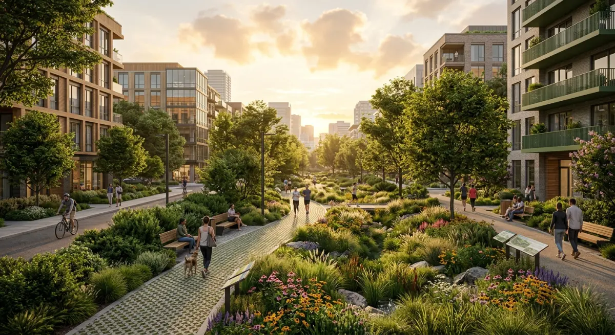
Aerial overviews are useful for communicating the extent of a green infrastructure network. But they don’t communicate whether a space feels pleasant to walk through. Eye-level renders — positioned at pedestrian height, showing real-feeling light, shadow, materiality, and populated with people going about ordinary activities — do the emotional work that top-down views can’t. A parent walking past a rain garden with a child. A cyclist using a shaded green corridor. These figures aren’t decoration. They’re the committee’s surrogate self in the render, and their presence communicates safety, scale, and desirability simultaneously.
Before/After Comparative Renders
One of the most effective techniques we’ve seen landscape architects use is the before/after composite — a photo of the existing site condition alongside a photorealistic 3D render of the proposed condition from the same viewpoint. When a committee can see a barren car park transformed into a permeable paving scheme with tree pits and planted margins, the value of the green infrastructure proposal becomes concrete rather than abstract. This technique also addresses a common objection: “We’re not sure the existing character will be lost.” The side-by-side makes the relationship between old and new explicit.
Annotated Renders That Bridge Technical and Lay Understanding
One technique that works particularly well for green infrastructure is the annotated rendering — essentially a photorealistic image with clear, minimal callout labels identifying individual elements. “Permeable block paving,” “bioretention cell,” “native wildflower planting zone,” “tree pit with structural soil cell system.” These labels do something useful: they tell the committee that the design is technically thought-through without requiring them to read a 40-page drainage strategy. The render does the aesthetic work; the annotations do the technical reassurance. Together, they address both the emotional and the rational parts of a planning decision.
Aerial and Site-Wide Views: Communicating the Network, Not Just the Node
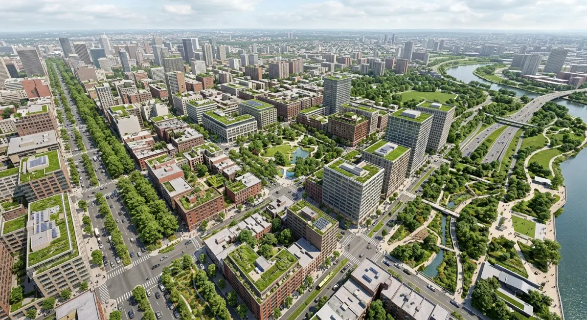
Green infrastructure is most powerful when it functions as a connected network — swales feeding into attenuation basins, green roofs feeding into planted courtyards, tree canopy corridors linking parks and streets. Individual 3D renders of single nodes miss this systemic story entirely. That’s where aerial 3d rendering becomes genuinely useful.
An aerial render at 30–60 metres elevation can show an entire development block with its green infrastructure strategy visible — where water flows, where trees are positioned for microclimate benefit, where the ecological corridors connect. It’s the kind of overview that a written masterplan chapter can describe but never adequately convey. For large-scale schemes, this aerial view often becomes the lead image in the planning submission — the image the committee returns to as a reference point throughout the meeting.
This connects directly to the challenge of presenting schemes at urban design scale. If you’re working on a project that involves multiple development phases across a large site, it’s worth understanding how 3d rendering for masterplan developments how urban designers present largescale mixeduse sites to local authorities has evolved — particularly around how green infrastructure networks within those masterplans get visualised for non-specialist audiences.
What Landscape Architects Often Get Wrong in Their Rendering Briefs
We’ve received briefs that specify every tree species, soil depth, and drainage coefficient — and then forget to mention what the render is actually for. A rendering brief that doesn’t account for the audience will often produce technically accurate but communicatively ineffective images.
Here are the most common mistakes we see:
| Common Mistake | Why It Matters | What to Do Instead |
|---|---|---|
| Only commissioning bird’s-eye renders | Committees can’t experience scale or atmosphere from above | Always include at least one eye-level pedestrian view |
| Using placeholder or generic vegetation assets | Wrong plant forms undermine ecological credibility | Provide species-accurate planting references to the studio |
| Rendering at planting-day condition only | Makes the scheme look sparse and unconvincing | Request 5-year or 10-year maturity renders |
| Omitting people and activity | Space feels abstract and uninhabited | Specify realistic user populations in the brief |
| Choosing wrong time of day / lighting | Flat midday light loses depth and atmosphere | Opt for golden hour or overcast light for planted landscapes |
| Not specifying surrounding context | Green infrastructure floats without the urban fabric around it | Provide OS data, photos, and adjoining building information |
The brief is where most rendering projects succeed or fail. If you’re unsure how to structure one effectively, the guide on how to brief a 3d rendering studio what architects and developers need to prepare before project kickoff is a good starting point.
Rendering Style: Photorealistic vs Illustrative for Planning Submissions
There’s a legitimate debate in landscape architecture about whether planning renderings should be photorealistic or stylised. Some practitioners worry that highly photorealistic renders make commitments feel more final — that committees will hold you to the exact appearance rather than the design intent. Others argue that stylised renders (sketch overlays, watercolour treatments) feel less credible and get less serious consideration.
In our experience, the sweet spot for green infrastructure in planning submissions is a render that reads as photorealistic in its spatial relationships and planting character, but doesn’t try to pass itself off as a photograph. Clean, accurate lighting. Real-feeling vegetation. Correct material reads on hard landscape. But with a slightly extended depth of field or a soft atmospheric haze that signals “this is a design visualisation, not a guaranteed outcome.” That framing actually protects the landscape architect while still giving the committee enough visual information to make a confident decision.
The topic of rendering style and its impact on planning outcomes is explored in more depth in residential exterior rendering styles compared photorealistic vs sketch vs watercolour which wins planning committees — much of that analysis applies equally to landscape-led schemes.
When to Use Animation or Walkthroughs for Green Infrastructure Presentations
Static renders are sufficient for most planning submissions. But for complex green infrastructure schemes — particularly urban parks, waterfront regeneration, or biodiversity corridor proposals — a short animated walkthrough can be the difference between a committee that understands the proposal and one that asks for further information before voting.
The reason is sequence. A walkthrough lets the committee experience a designed journey through the landscape — entering through a planted gateway, moving along a bioswale-lined path, reaching a central rain garden square, exiting through a shaded canopy corridor. That narrative arc communicates the design intent in a way that even six static renders cannot. It also communicates scale sequentially, which is something static images always struggle with.
The right format depends on budget, timeline, and the complexity of the scheme. Aerial rendering vs site plan drawings what mixeduse developers are using to get schemes approved faster offers some useful context on format decisions for planning applications specifically — and the logic applies well to landscape-led submissions too.
What Makes a Green Infrastructure Rendering Credible, Not Just Pretty
Planning committees are increasingly experienced with professional renderings. They’ve seen overpromised visuals that delivered disappointing built outcomes. That history makes them appropriately skeptical of images that look too polished, too perfect, too unlike any real landscape they’ve ever walked through.
Credibility in a green infrastructure rendering comes from specificity. The planting should look like the species specified, not generic 3D tree assets. The materiality of permeable paving should reflect actual product specifications. The scale of drainage elements should be consistent with what the engineering drawings show. Water elements — if the scheme includes ponds, rill features, or wet-planted areas — should reflect realistic water levels and planting establishment, not an idealized surface reflection.
When a committee asks “Is this what it will actually look like?” and the landscape architect can say “Yes — the species, the materials, the scale — all of this is drawn directly from the specification documents,” that’s a fundamentally different conversation than “This is an artist’s impression.” One builds trust. The other invites doubt.
Conclusion: The Rendering Is Part of the Design Argument
Green infrastructure proposals deserve the same visual investment as the buildings around them. In fact, given how difficult these systems are to communicate through technical drawings alone, the case for quality 3D exterior visuals is arguably stronger for landscape-led schemes than for any other planning submission type.
The most effective approach isn’t simply producing beautiful images. It’s treating the rendering as an extension of the design argument — using specific species, accurate materials, realistic maturity states, and genuine context to make the committee feel confident about what they’re approving. That’s the practical difference between a rendering that gets a scheme through planning and one that gets a request for further information.
If you’re working on a green infrastructure scheme and need exterior renderings that can genuinely perform in a planning committee setting, we’d be glad to talk through what your project needs. Visit our commercial exterior rendering service page to see examples of the kind of work we produce for landscape and urban design clients — or contact us directly to discuss your project brief.
Frequently Asked Questions
What types of green infrastructure features can landscape architects show in 3D exterior renderings for planning committees?
Landscape architects can visualize a wide range of green infrastructure elements in 3D exterior renderings, including bioswales, green roofs, permeable pavements, rain gardens, urban tree canopies, and living walls. These renderings allow planning committees to see how stormwater management systems, native plantings, and ecological corridors will look and function within the actual site context. By presenting these features in photorealistic detail, landscape architects make it easier for non-technical reviewers to understand the environmental and aesthetic benefits of each design choice.
How do 3D exterior renderings help landscape architects get planning committee approval faster?
3D exterior renderings eliminate ambiguity by replacing complex technical drawings and CAD plans with intuitive, photorealistic visuals that planning committee members can immediately understand without specialized training. When decision-makers can clearly see how a green infrastructure project will look, feel, and integrate with the surrounding neighborhood, they are more likely to ask focused questions and reach consensus quickly. Studies and industry reports consistently show that projects presented with high-quality renderings experience fewer revision cycles and shorter approval timelines compared to those relying solely on 2D plans.
What is the difference between 3D exterior renderings and traditional landscape drawings when presenting green infrastructure projects?
Traditional landscape drawings, such as plan views, sections, and elevations, require significant technical literacy to interpret and often fail to convey the experiential quality of a green infrastructure design. 3D exterior renderings, by contrast, simulate realistic lighting, seasonal vegetation changes, material textures, and human scale, giving planning committees a true sense of how the finished project will look and perform. This shift from abstract representation to immersive visualization dramatically improves stakeholder comprehension and supports more informed, confident decision-making during the review process.
Can 3D exterior renderings show how green infrastructure performs during different weather or seasonal conditions?
Yes, advanced 3D exterior renderings can depict green infrastructure in multiple seasonal states, showing how bioswales manage stormwater during heavy rain, how deciduous trees provide summer shade while allowing winter sunlight, and how native plant communities transition across growing seasons. Landscape architects use these seasonal and weather-scenario visualizations to demonstrate the functional resilience of their designs to planning committees who may have concerns about long-term performance. This capability is especially valuable for illustrating climate adaptation strategies and building committee confidence that the green infrastructure will deliver year-round ecological benefits.
How much do 3D exterior renderings cost for landscape architecture projects involving green infrastructure planning submissions?
The cost of 3D exterior renderings for landscape architecture projects typically ranges from $500 to $5,000 or more per image, depending on the complexity of the scene, level of photorealism required, and whether animations or interactive walkthroughs are included. For green infrastructure planning submissions, landscape architects often commission a package of three to six key viewpoints that capture the most critical design moments, such as entry sequences, stormwater features, and community gathering spaces. While the upfront investment may seem significant, the cost is frequently offset by faster approvals, reduced revision rounds, and stronger stakeholder buy-in that keeps projects on schedule and within budget.