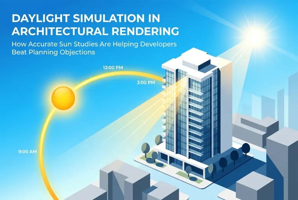
Planning committees are not easy rooms to win over. There’s always someone in the meeting who wants to know what your building will do to the light on the street, to the garden next door, or to the public square it faces. That question used to be answered with hand-drawn shadow diagrams and a lot of verbal reassurance. It wasn’t enough then, and it’s even less convincing now. Daylight simulation in architectural rendering — and specifically how accurate sun studies are helping developers beat planning objections — has quietly become one of the most requested services we handle at 360archviz.com. Not because it’s a trend, but because it works. Planners, objectors, and even judges in planning appeals respond to visual evidence. Showing them exactly where shadows fall at 9am in December, at noon in June, and at 5pm in September is a different category of argument than anything a written report alone can achieve.
Sun studies used to be a nice-to-have. A polished extra that went into the planning pack if there was budget left over. That’s changed. We’re seeing more applications where accurate daylight analysis is specifically requested in pre-application advice from local planning authorities. Sometimes it’s mandatory. More often it’s not required but the absence of it becomes a weak point that objectors exploit. A neighbour submitting an objection saying “this building will block all our light” is a lot harder to dismiss when you haven’t provided data that directly addresses the claim.
The good news is that the tools available to a professional rendering studio now make it possible to produce sun studies that are physically accurate and visually clear enough for a non-technical audience to understand immediately. This post explains how that process works, what it actually shows, and where developers tend to make avoidable mistakes when commissioning this kind of work.
What Daylight Simulation Actually Means in a 3D Rendering Context
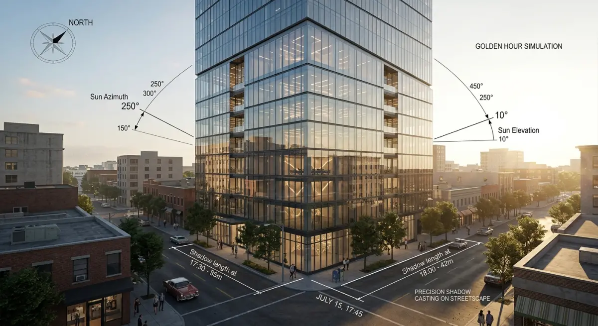
There’s a distinction worth making early. A lot of renderings show sunlight — warm afternoon light hitting a facade, dappled shadows across a terrace. That’s atmospheric. It looks good. But it’s not necessarily a sun study. Daylight simulation in architectural rendering in the technical sense means using the actual geographic coordinates of the site, the correct time of year, and the real solar angles for that location to render precisely where sunlight falls and where shadows are cast at specific moments in time.
In our studio we use tools like 3ds Max with V-Ray or Corona Renderer combined with accurate sun-sky models that take GPS coordinates and calendar dates as inputs. When we build a sun study for a site in Manchester, the solar path is different from the same study for a site in Dubai or Sydney. The software accounts for this. The rendered output isn’t an approximation — it’s the physical behaviour of sunlight modelled mathematically, then presented as a photorealistic image or animation sequence.
A proper sun study typically includes a sequence of still frames showing shadow behaviour at intervals across a single day (often hourly from sunrise to sunset), at multiple dates across the year. Summer solstice, winter solstice, and the equinoxes are standard. Some planning authorities also want specific dates that relate to building regulations — BS 8206-2 in the UK sets reference criteria for daylight and sunlight that planning consultants and councils use to evaluate applications.
How Accurate Sun Studies Are Helping Developers Beat Planning Objections
The most common planning objection related to light goes something like this: “The proposed development will cast unacceptable shadow over neighbouring properties, reducing daylight and sunlight to an unreasonable degree.” It’s a legitimate concern and one that can genuinely affect lives. The problem for developers is that the objection is often stated in vague, emotional terms — and if the planning submission doesn’t have precise counter-evidence, it can carry more weight than it deserves.
An accurate sun study addresses this directly. Instead of a written rebuttal saying “the impact on neighbouring daylight will be minimal,” you submit a rendered sequence showing the shadow path across the year. If the analysis shows that a neighbouring garden loses direct sunlight for two hours on a winter afternoon but retains it throughout summer mornings, that’s a specific, reviewable, defensible position. The objector’s claim becomes testable against actual data rather than competing with it.
We’ve worked on planning packs where the sun study was arguably the single document that moved the committee. Not because it was beautiful — though the renders were clean and professional — but because it answered the question before it was asked. The planning officer and the committee members could see, in plain images, that the shadow impact was within acceptable bounds. It’s a different kind of persuasion from a written statement, and in our experience it’s more effective with mixed audiences who include people who aren’t trained to read technical text.
This is also relevant beyond residential developments. For larger mixed-use schemes, the daylight analysis needs to consider multiple affected neighbours at once — and aerial rendering vs site plan drawings what mixed-use developers are using to get schemes approved faster is something worth understanding in that context, because aerial-perspective sun studies give committees the full spatial picture of how shadow moves across a neighbourhood, not just a single elevation.
The Technical Setup: What Goes Into a Proper Sun Study
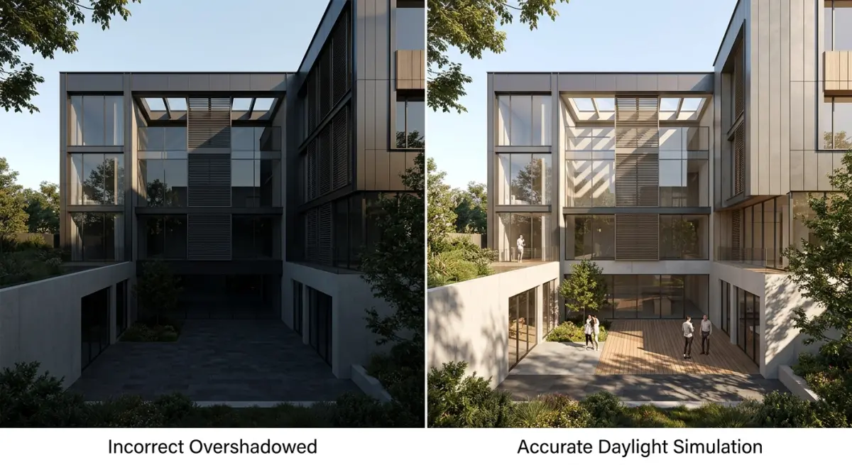
A sun study is only as accurate as the model it’s run on. This is where a lot of submissions fall short. If the 3D model of the proposed building is roughly correct but the surrounding context is missing or approximated, the shadow analysis is useless. Real shadow impact depends on the existing buildings, topography, and vegetation on and around the site.
Here’s what a complete setup requires:
| Element | Why It Matters | Data Source |
|---|---|---|
| Proposed building model | Must reflect accurate floor-to-floor heights and massing | Architect’s CAD / BIM files |
| Surrounding context model | Existing buildings cast shadows too — ignoring them distorts results | OS data, Google Earth, site survey |
| Site coordinates (GPS) | Drives the solar angle calculations for the specific location | Ordnance Survey / Google Maps |
| Ground plane and topography | Slopes affect where shadows fall, especially in hilly areas | Site survey, LIDAR data where available |
| Analysis dates and times | Standardised dates allow comparison against planning benchmarks | BRE guidelines / planning authority brief |
If a developer sends us only the proposed building model and asks for a sun study, we flag immediately that the surrounding context needs to be modelled too. It takes more time and it costs more. But a sun study without accurate context isn’t just incomplete — it can actively misrepresent the situation, which is a problem if the submission gets scrutinised.
The output format also matters. A single rendered image showing noon on the summer solstice is not a sun study in any useful sense. A proper deliverable includes a sequence — often 12 to 24 frames per date, across three or four key dates — plus an animated video that shows shadow movement across the day in a continuous loop. Planners and committee members respond strongly to the animated version because it’s intuitive. You watch the shadow move. You don’t have to interpret anything.
Daylight vs Sunlight: A Distinction That Matters in Planning
Planning consultants will sometimes correct clients on this, but it’s worth understanding from the start. Daylight and sunlight are assessed differently under planning guidelines. Daylight refers to the amount of diffuse sky light that reaches a window or internal space — it’s relevant even on overcast days. Sunlight refers specifically to direct solar illumination, and it’s typically assessed against criteria like the hours of sunlight a window or amenity space receives on key dates.
A sun study in the rendered sense addresses sunlight — direct solar access and shadow casting. A full daylight assessment (often done by specialist planning consultants using tools like VELUX Daylight Visualizer or Radiance) models diffuse light, Average Daylight Factor, and similar metrics. These are different things, and a planning application for a scheme with significant overlooking potential may need both.
In our experience, architects and developers sometimes assume the rendered sun study covers everything. It covers shadow and direct sunlight well. It doesn’t replace a formal daylight and sunlight report from a qualified consultant if one is required. The two documents work best together — the consultant’s report provides the technical metric compliance, and the rendered sun study provides the visual evidence that brings those numbers to life for a non-specialist audience.
What Clients Get Wrong When Commissioning Sun Studies
The most frequent mistake is leaving it too late. A sun study needs time — not just for rendering, but for sourcing the context data, building the surrounding model, aligning the coordinate system, and running the sequence across multiple dates and times. If a developer comes to us two weeks before a planning submission deadline, we can often deliver, but it’s tight. If something needs to be revised because the architect changed the massing, that revision has to flow through the entire sequence. Understanding how long does architectural 3d rendering actually take a project-by-project turnaround guide is genuinely useful before you set your submission timeline.
The second mistake is treating the sun study as a marketing image. Sun studies for planning should look professional and clear, but they’re not the place for warm sunset tones, dramatic lens flares, or lifestyle overlays. Planners and consultants are looking at these images critically. If the rendering looks styled rather than accurate, it invites doubt. We keep sun study renders clean — neutral sky conditions, consistent lighting, accurate shadows, clear timestamp annotations on each frame.
Third: not annotating the outputs. Each frame should clearly state the date, the time, and the compass orientation. If you’re submitting a sequence of 24 frames across a day and the committee member can’t tell what time each one represents, the analysis loses half its value. Labels matter. North arrows matter. Scale references matter.
For developers working across different building types — from residential to more specialised developments — understanding what planners look for is worth going deeper on. The principles discussed in exterior 3d rendering for planning permission what councils actually look for in visualisations applies directly to how sun study outputs should be framed and presented within a planning pack.
When Sun Studies Become Part of a Larger Visualisation Strategy
Sun studies don’t exist in isolation. They’re most effective when the planning pack around them is also well-prepared. A developer submitting a strong daylight simulation alongside a clear aerial 3d rendering of the site in context gives the planning committee everything they need to understand the proposal spatially — from above, from street level, and across time. Each visualisation type answers a different question. The aerial shows massing and context. The exterior render shows materiality and street presence. The sun study shows light and shadow impact.
For developers working on education or accommodation schemes — where daylight to amenity spaces and study rooms is specifically regulated — the sun study becomes even more central. The considerations around 3d rendering for student accommodation developments what pbsa investors and university partners need to see at preapproval stage include daylight evidence as a key component of what planning authorities and investors want to see before approval.
The rendering style matters too. We’ve written about how residential exterior rendering styles compared photorealistic vs sketch vs watercolour which wins planning committees — and the same logic applies to sun studies. For planning purposes, photorealistic accuracy reads as evidence. Illustrative styles read as artistic impression. When you’re dealing with shadow impact objections, you want the former.
Conclusion
Daylight simulation in architectural rendering is no longer an optional extra for complex applications. It’s a direct response to one of the most common and emotionally charged categories of planning objection. When a developer can show — in photorealistic, time-stamped, geographically accurate rendered sequences — exactly what shadow impact a building creates and when, the conversation changes. Objectors lose a key argument. Committees gain the confidence to make a decision based on evidence rather than anxiety.
The key is doing it properly. Accurate context modelling, correct coordinates, the right date and time sequences, clean professional output without stylistic embellishment, and clear annotation throughout. Done well, a sun study doesn’t just support a planning application — it actively defends it.
If you’re preparing a planning submission and need daylight and sun study visualisations produced to a standard that will hold up to scrutiny, contact us at 360archviz.com and we’ll talk through what your application needs and how to structure the deliverables.
Frequently Asked Questions
How accurate are daylight simulations in predicting real-world sunlight conditions after a building is constructed?
Modern daylight simulations are highly accurate when based on correct inputs, including precise geographic location, verified building geometry, accurate material reflectance values, and reliable local climate or TMY weather data. Studies comparing simulation predictions to post-occupancy measurements consistently show deviations of less than 10-15% for key metrics like Daylight Factor and Annual Sunlight Exposure when models are properly calibrated. The main sources of inaccuracy tend to be simplified material assumptions or incomplete modeling of surrounding context buildings, which is why experienced visualization teams invest significant effort in capturing the full neighborhood environment rather than isolating the proposed structure.